
When most people begin to plan a construction project, their only concern is cost. How much will it cost to build the building? Hiring surveyors for field work will take a lot of time and money. Sure. But not if you use drone land surveys. Drone land surveying is much cheaper than conventional methods, and here are 10 reasons you should use drone surveys before construction.
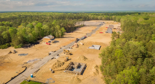
Get High-Resolution Aerial Imagery
You can get high-resolution aerial imagery of your property and land using a drone. The images will give you a good idea of the topography and terrain of the area, which can be useful when planning how to construct your building or home.
Map a Construction Site in Real-Time
The first benefit of using drone surveys for construction is that they allow you to map out the layout of your project more accurately than ever before. A traditional surveyor would have to use markings on the ground or pins in the ground, but these methods aren’t always accurate enough for such a large project. With a drone, though, there’s no need for such complicated methods — all you need is an aerial view of the area being surveyed and some basic software that can process this data into a usable format for construction purposes.
Submit Your Plans Electronically to Approval Boards
Electronic documents are easier to find than paper copies. For example, if you have a digital copy of a plan, it’s easy to find that file and send it to someone else. But if you send a hard copy of a plan through the mail, there’s no way for that person to easily find it again later on if they need it.
Receive Accurate Measurements for a Site
Drones have been used for aerial photography for many years, but recently they’ve been adapted for other uses, including unmanned aerial vehicles (UAVs) or drones. UAVs are equipped with high-accuracy GPS systems, gyroscopes and other sensors that allow them to fly autonomously through an area and collect data about it. Unlike traditional land surveying techniques, which involve a crew walking around with global positioning system (GPS) units and measuring tapes, drone land surveying is much more precise — often within one centimetre of accuracy. This makes it ideal for industries such as construction and mining, where accuracy is critical when determining how much material needs to be excavated or moved around on site.
Safely Monitor Day-to-Day Construction Progress
Drones can capture high-quality images of the land from above, providing an aerial view of what’s going on at your construction site. This means you can see exactly how work is progressing daily and make better decisions about how things are going.
Use Drones for Determining the Lateral Bearing Capacity of Soil at a Site
The drone land surveying technique can be used to determine the lateral bearing capacity of soil at a site. This method uses radar signals transmitted from a drone flying overhead to detect changes in elevation on the surface below. The drone’s position and altitude are tracked by GPS sensors and compared with data from earlier flights to determine if any change has occurred.
Monitor Stockpile Volumes Remotely and Safely
Drones are a great tool for land surveying because they can quickly cover large areas without causing damage to workers or equipment. They also provide a bird’s eye view of stockpiles, which helps monitor the quantity and quality of materials in storage.
Drone land surveying can show you a better, more specific picture of what your site will look like before construction ever begins. As a result, you’ll have a better idea of the work that needs to be done. This can make things quicker, easier and cheaper.